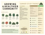
The intent of the Shade Tree Planting Prioritization (STPP) analysis is to:
- Rapidly and strategically assess Arizona’s urban forest communities to inform Urban and Community Forestry planning
- Identify Arizona’s underserved cities and communities based on state-wide, best available, and relevant socio-economic and environmental data
- Account for a city’s commitment to their urban forest (sustainability) as it applies to UCF partnerships and projects
- Keep spatial and quantitative analysis simple and transparent
- Generate summaries and geospatial products for internal and public dissemination
The analysis and products will inform future DFFM priorities for program delivery and may be used directly by communities for their management needs.
How Can The Prioritization Maps Help Me?
| Resident |
Compare neighborhoods and inform community action |
| HOA |
Justify shade tree planting and maintenance costs |
| Municipality |
Identify underserved neighborhoods and promote shade tree planting and maintenance |
| Non-profit |
Target and maximize volunteer tree planting and care efforts |
| Business |
Identify potential markets for tree nurseries ("hot" spots)
Identify areas with possibly larger tree maintenance needs ("cool" spots) |
Regional Planning Organizations
(RTA, MAG, PAG, etc.) |
Support long-term planning initiatives
Aide obtaining funding for specific projects |
 Major funding provided by the USDA Forest Service State and Private Forestry Program.
In accordance with Federal law and U.S. Department of Agriculture policy, this institution is prohibited from discriminating on the basis of race, color, national origin, sex, age, or disability. (Not all prohibited bases apply to all programs.)
Use Disclaimer
Use is granted to public agencies, educational institutions, non-profit organizations and private individuals for non-commercial purposes. For commercial use of the Department of Forestry and Fire Management maps and data see Arizona Revised Statutes 39-121.03. The Department makes no warranties, implied or expressed, with respect to the accuracy of and the use of this data for any specific purpose. Users are required to make their own assessment of the data for any specific use.
Disclaimer Of Non-Endorsement
References herein to any specific commercial products, process, or service by trade name, trademark, manufacturer, or otherwise, does not necessarily constitute or imply its endorsement, recommendation, or favoring by the Department or USDA Forest Service. The views and opinions of individuals expressed herein do not necessarily state or reflect those of the Department or USDA Forest Service, and shall not be used for advertising or product-endorsement purposes.
Geospatial Disclaimer
Property line representations and/or any other type of boundary, linear or point location representations contained within this data or displayed within this product are approximate, and cannot be used for authoritative location purposes. Users should independently research, investigate and verify all information before relying on it or using it in the preparation of legal documents. Legally-defensible property boundaries can only be established by state-registered professional land surveyors. A list of Arizona Registered Land Surveyors is available at btr.az.gov.


 Reports
 Archived Urban Tree Talk Newsletters