  • State of Arizona
  • Visit OpenBooks
  • Ombudsman Citizens Aide
  • Register to Vote
Department of Forestry and Fire Management Logo
Department of Forestry and Fire Management
  • Home
  • Newsroom
    • Public Affairs
    • Fire Restrictions
    • Public Records
  • Fire
    • Wildland Fire Suppression
    • Prevention
    • Wildfire Information
      • Tips
      • Be Ready
      • Drones and Wildfire
    • State Forestry Crews
    • Cooperators and Fire Business
      • Fire Business Systems - Program Training
      • Emergency Medical Services on Federal Lands
      • Wildfire Equipment Program
    • Dispatch
    • Training
  • Forestry
    • Tree Care
    • Urban and Community Forestry
    • Stewardship
    • Legacy
    • Forest and Woodland Health
    • Utilization and Marketing
  • Grants
    • Community Forestry Grants
    • Forest Health Grants
      • Western Bark Beetle Initiative Grants
      • Invasive Plant Grants
    • Training and Equipment
      • 2024 American Rescue Plan Act (ARPA) Grant
    • Hazard Fuels Mitigation
    • Forest Utilization Grants
    • Landscape Scale Restoration Grants
    • Post-Wildfire Infrastructure Assistance Program
  • All Hazard Response
  • Fire Marshal
    • Arizona State Statute and Fire Code
    • Plan Review - Permitting and Inspection Information
    • Fire Safe Cigarettes
      • FSC Compliance and Forms
    • Food Truck Inspection, Letter of Appointment (LOA), Trampoline Courts
    • Firefighter Relief and Pension Fund
    • Arizona NFIRS: National Fire Incident Reporting System
    • Fire Prevention
  • About
    • Contact Us
May 21, 2025 - Dry Conditions Trigger Fire Restrictions in Central and Western Arizona
May 12, 2025 - Fire Activity and Dry Conditions Prompt Stage 2 Fire Restrictions in Southeastern Arizona
Dry Conditions Statewide Could Fuel High Fire Activity Across Arizona
  • Home
  • Forestry
  • Urban & Community

Urban & Community

Montezuma Cypress - Fact Sheet

PDF icon Tour de Trees - Tree Fact Flyer - Montezuma Cypress.pdf
  • Read more about Montezuma Cypress - Fact Sheet

AZUTM Community Inventories

  • AZUTM Home
  • About
  • Resources
  • Upload
  • Community Inventories

i-Tree Logo

Custom i-Tree Streets Analysis for Arizona's Urban Forests

Once an urban tree inventory has been completed and submitted to the AZUTM website, the Department of Forestry and Fire Managment will process and analyze the submitted data with a customized i-Tree Streets software. i-Tree Streets provides structural and benefit analysis for urban forests. This free tool was developed and is maintained with the support of USDA Forest Service and can be downloaded at www.itreetools.org. See the Inventory Report Guide PDF below for detailed information on how to read and use the urban tree inventory reports.

  •  Understanding Your AZUTM Reports Guide  
  • Urban Canopy Cover Analysis Reports for Arizona's largest Cities and Towns 
  • Interactive AZUTM Tree Inventory Map and Arizona Urban Canopy Map 


Please email [email protected] to request completed reports.


Disclaimer of Non-endorsement

Reference herein to any specific commercial products, process, or service by trade name, trademark, manufacturer, or otherwise,does not necessarily constitute or imply its endorsement, recommendation, or favoring by the USDA Forest Service. The views and opinions of individuals expressed herein do not necessarily state or reflect those of the USDA Forest Service, and shall not be used for advertising or product-endorsement purposes. In accordance with Federal law and U.S. Department of Agriculture policy, this institution is prohibited from discriminating on the basis of race, color, national origin, sex, age, or disability. (Not all prohibited bases apply to all programs.)

  • Read more about AZUTM Community Inventories

AZUTM Resources

  • AZUTM Home
  • About
  • Resources
  • Upload
  • Community Inventories

I-Tree Streets Climate Zones in Arizona

Arizona Tree Guides

Urban tree field guides tailored for volunteers and citizen scientists in Arizona. The guides are split into three of i-Tree Streets climate zones but feel free to mix and match the guides for your community.
i-Tree Streets' economic and environmental tree value analysis are based on reference cities within STRATUM Climate Zones developed by USDA-FS. Not until you upload your data to AZUTM to run the analysis, do you have to decide on a climate zone.

 
PDF Download  AZUTM Field Guide - Southwest Desert  04 /28/2015
Tree identification guide for select horticultural tree species found in Arizona and listed in i-Tree Streets' Southwest Desert climate zone. 
PDF Download  AZUTM Field Guide - Interior West  04/28/2015
Tree identification guide for select horticultural tree species found in Arizona and listed in i-Tree Streets' Interior West climate zone.
PDF Download  AZUTM Field Guide - North  04/28/2015
Tree identification guide for select horticultural tree species found in Arizona and listed in i-Tree Streets' North climate zone.
PDF Download  AZUTM Field Guide - Insects and Diseases   05/21/2015
Guide to common insect and diseases that affect Arizona's horticultural trees.
PDF Download  AZUTM Master Tree Index - 06/01/2015 
Master index of tree species found in AZUTM Guides listing their scientific names, common names, species codes, and page numbers.

Tree Inventory Guides and Templates

How-to manuals for tree inventories and template files for communities to get a leg up on their own urban forest inventories. Feel free to modify the template files to your liking. See the "AZUTM - Tree Inventor Instruction Guide" for detailed instructions.

PDF Download  AZUTM Tree Inventory Instruction Guide  5/15/2015 
Inventory and technical manual on how to collect tree measurements, observations, and how to submit inventories to AZUTM for analysis. 

PDF Download  Understanding Your AZUTM Reports Guide  9/28/2015
Guide to AZUTM's custom i-Tree Streets reports with tree structure and benefits analysis results for your submitted tree inventories. 

Download Word document  AZUTM Tree Data Collection Form Template  12/15/2014
Paper-based data collection template used in the field.

Download Excel document  AZUTM Tree Inventory Spreadsheet Template  02/04/2015
MS Excel spreadsheet template used to digitally summarize tree inventories and upload to AZUTM's tree structure and benefits analysis tool.

Download Excel document  AZUTM DBH Calculator 09/29/2015 
MS Excel spreadsheet that helps calculate the combined Diameter at Breast Height (DBH) of trees with multiple trunks.

Arizona Urban Tree Canopy Cover Analysis

i-Tree Canopy analysis reports (PDF) for Arizona's largest Cities and Towns. The 2015 analysis reports provide % tree canopy cover and tree benefit estimates for over 97 communities and were used to estimate the average urban tree canopy cover for Arizona's Counties. See reports below or AZUTM Interactive Maps.

The canopy cover estimates should not be taken as an absolutes but as a comparative estimate between Arizona’s major towns and cities.

  • Download Excel document 2016 Arizona Urban Tree Canopy Cover by County Summary Table
  • Download Excel document 2016 Arizona Urban Tree Canopy Cover by City Summary Table

The i-Tree Canopy analysis were based on municipal incorporated areas unless otherwise stated.

  • Urban = 2010 Census Urban Areas
  • Intersection = intersection between Census Urban Areas and incorportated areas.

PDF Download Canopy Cover Reports A - G

PDF Download Canopy Cover Reports H - R

PDF Download Canopy Cover Reports S - Z

  • Apache Junction
  • Avondale (Intersection)
  • Benson (Intersection) 
  • Bisbee (Urban)
  • Blyth (Urban)
  • Buckeye (Urban)
  • AZUTM_i-Tree_Canopy_report_BullheadCity.pdfBullhead City (Intersection)
  • Camp Verde (Urban)
  • Carefree (Intersection)
  • Casa Grande (Urban)
  • Cave Creek
  • Chandler (Urban)
  • Chinle (Intersection)
  • Chino Valley (Intersection)
  • Clarkdale (Intersection)
  • Clifton (Urban)
  • Colorado City
  • Coolidge
  • Cottonwood (Intersection)
  • Dewey Humboldt
  • Douglas (Intersection)
  • Duncan
  • Eager
  • El Mirage
  • Eloy (Intersection)
  • Flagstaff (Urban)
  • Florence (Urban)
  • Fountain Hills
  • Fredonia
  • Gila Bend
  • Gilbert
  • Glendale
  • Globe
  • Goodyear (Intersection)
  • Green Valley (Intersection, 2017 update)
  • Guadalupe
  • Hayden
  • Holbrook (Intersection)
  • Huachuca City
  • Jerome
  • Kayenta (Urban)
  • Kearny
  • Kingman
  • Lake Havasu City (Urban)
  • Litchfield Park
  • Mammoth
  • Marana (Intersection)
  • AZUTM_i-Tree_Canopy_report_Maricopa.pdfMaricopa (Intersection)
  • Mesa
  • AZUTM_i-Tree_Canopy_report_Miami.pdfMiami (Intersection)
  • Nogales (Urban)
  • Oro Valleye
  • Page (Intersection)
  • Paradise Valley
  • Parker (Intersection)
  • Patagonia
  • Payson (Urban)
  • Peoria
  • Phoenix
  • Pima (Intersection)
  • Pinetop Lakeside
  • Prescott
  • Prescott Valley (Intersection)
  • Quartzsite (Urban)
  • Queen Creek
  • Safford (Urban)
  • Sahuarita (intersection, 2017 update)
  • San Carlos (Urban)
  • San Luis (Intersection)
  • Scottsdale
  • Sedona (Urban)
  • Show Low
  • Sierra Vista
  • Snowflake
  • Somerton (Intersection)
  • South Tucson
  • Springerville
  • Star Valley
  • St. Johns (Intersection)
  • AZUTM_i-Tree_Canopy_report_Superior.pdfSuperior (Intersection)
  • Surprise
  • Taylor (Intersection)
  • Tempe
  • Thatcher (Intersection)
  • Tolleson
  • Tombstone
  • Tucson (Intersection)
  • Tusayan
  • University of Arizona Planning Area
  • Wellton
  • Wickenburg (Intersection)
  • Willcox (Intersection)
  • Williams (Intersection)
  • Winkelman
  • Winslow (Intersection)
  • Youngtown
  • Yuma (Urban)

Urban and Community Forestry Documents

  • PDF Download AZSF - Urban Forests Needs Assessment 2012  

Online Resources

Following are links to helpful urban tree inventory related resources:

  • Tree Identification & Species Codes
    • USDA-NRCS PLANTS Database - Lookup USDA species codes and more!
  • Tree Identification
    • Encyclopedia of Life
    • Gymnosperm Database
    • Department of Horticulture, Oregon State University
    • SEINet Southwest Environmental Information Network
    • SelecTree
    • Tropicos
    • University of Arizona Campus Arboretum
    • Forest Resources and Environmental Conservation, Virginia Tech
  • Insect and Diseases
    • BugGuide.net
    • BugWood.org
  • Valuing Tree Benefits
    • i-Tree Streets
    • National Tree Benefit Calculator
  • Miscellaneous
    • Forestry Images 
    • 2010 USDA FS Urban Forest Analysis  

Mobile Tree Inventory Apps

For volunteer-driven inventories, we continue to search for an affordable smartphone app and web-based data storage service that allows for customized tree inventory and GPS location capture under intermittent network conditions. Here are some partial solutions:

  • GIS Cloud - commercial online service for creating and managing custom mobile forms and collaborative maps; also collects GPS location, photos, audio, etc.; works offline
  • i-Tree Mobile Data Collection - free, mobile data collection web application that ties in with i-Tree Streets and Eco; requires constant internet access
  • Open Data Kit (ODK) - free, open-source tool set for mobile data collection solutions; requires moderate software configuration skills and your own ODK web server
  • Tree Plotter (Plan-It Geo) - fully featured commercial online service; requires constant internet access
  • OpenTreeMap.org - commercial crowd-sourcing online service; requires constant internet access
  • DoForms.com - commercial online service for creating and managing custom mobile forms that can work offline

Disclaimer of Non-endorsement

Reference herein to any specific commercial products, process, or service by trade name, trademark, manufacturer, or otherwise, does not necessarily constitute or imply its endorsement, recommendation, or favoring by the Arizona Department of Forestry and Fire Management.. The views and opinions of individuals expressed herein do not necessarily state or reflect those of the agency, and shall not be used for advertising or product-endorsement purposes.
In accordance with Federal law and U.S. Department of Agriculture policy, this institution is prohibited from discriminating on the basis of race, color, national origin, sex, age, or disability. (Not all prohibited bases apply to all programs.) 

  • Read more about AZUTM Resources

About AZUTM

  • AZUTM Home
  • About
  • Resources
  • Upload
  • Community Inventories

Urban Forest Resource Inventories

The Arizona Urban Tree Map (AZUTM) is part of the Urban Forest Resource Inventories (UFRI), a joint project of the Arizona State Forestry and USDA Forest Service.

The main goals of the project are to:

  1. compile existing urban forest inventory and resource information from communities, towns, and rural areas statewide;
  2. develop and implement a pilot project for gathering data in multiple Arizona communities; and
  3. develop and implement protocols and opportunities for community engagement and long-term urban forest sustainability.

The project goal is to develop an accessible tool that compiles statewide urban forest inventory information, including summary reports of the combined economic and environmental value of Arizona's urban forests. A baseline knowledge of Arizona's urban forests will enable Arizona State Forestry to identify where data and resource gaps exist, develop long-range goals for urban forests, compile statewide canopy cover information, and to provide regular and updated information for multiple needs. 

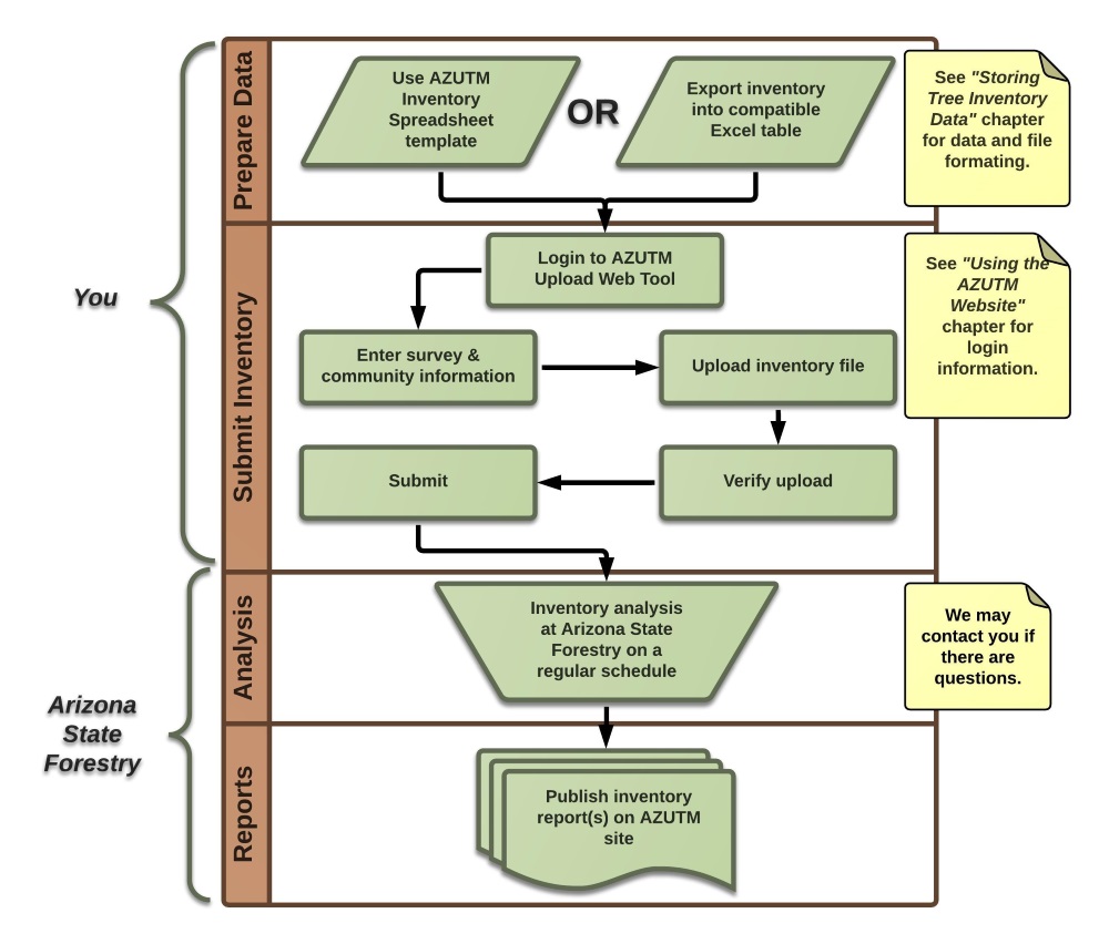
Arizona Urban Tree Map Analysis Service

See AZUTM Tree Inventory Instruction Guide for detailed information.
AZUTM Tree Inventory Upload Steps Diagram

Contributors

Arizona State Forestry:
Chris Erickson, Wolfgang Grunberg, John Richardson, Alix Rogstad

University of Arizona:
Cori Dolan, Randy Gimblett, Susan Kaplan, Tanya Quist, Matt Rahr, Mickey Reed, Alan Shoults, Craig Wissler

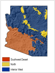
AZUTM Pilot Communities

  • Arizona State Parks - Oracle State Park
  • Town of Bisbee
  • City of Mesa
  • Town of Pinetop - Lakeside
  • Lake Havasu City
  • Town of Prescott Valley
  • University of Arizona Campus Arboretum

Funding

Major Funding Provided By: USDA Forest Service

Contact

Email:

Office: (602) 771-1400

Disclaimer of Non-endorsement

Reference herein to any specific commercial products, process, or service by trade name, trademark, manufacturer, or otherwise, does not necessarily constitute or imply its endorsement, recommendation, or favoring by the USDA Forest Service. The views and opinions of individuals expressed herein do not necessarily state or reflect those of the USDA Forest Service, and shall not be used for advertising or product-endorsement purposes.
In accordance with Federal law and U.S. Department of Agriculture policy, this institution is prohibited from discriminating on the basis of race, color, national origin, sex, age, or disability. (Not all prohibited bases apply to all programs.)

  • Read more about About AZUTM

Arizona Urban Tree Map (AZUTM)

  • AZUTM Home
  • About
  • Resources
  • Upload
  • Community Inventories

Arizona Urban Tree Map

Arizona Urban Canopy Map


The Arizona Urban Tree Map (AZUTM) is part of the Urban Forest Resource Inventories (UFRI), a joint project of the Arizona State Forestry and USDA Forest Service. The main goals of the project are to:

  1. support communities throughout Arizona in conducting urban forest inventories and
  2. compile a database of inventory information, local forest resource information, strategies for public involvement and a sustainable plan to enable long-term urban forest management.


Project Partners

  • Arizona State Forestry

  • University of Arizona.

Pilot Communities

Arizona State Parks - Oracle State Park Pinal County
Town of Bisbee Cochise County
City of Mesa Maricopa County
Town of Pinetop-Lakeside Navajo County
Lake Havasu City Mohave County
Town of Prescott Valley Yavapai County
University of Arizona Campus Arboretum Pima County


The Arizona Urban Tree Map is supported by USDA Forest Service funding. 

The Department of Forestry and Fire management complies with USDA Equal Opportunity and Non-Discrimination requirements. 


  • Read more about Arizona Urban Tree Map (AZUTM)

Tree Selection and Care

Proper tree selection, placement and care will serve your tree well through the years, allowing your tree to grow to its fullest potential. Selecting the right tree and location can help reduce maintenance issues down the road and will promote a healthy and vigorous tree. 

  • Ask an Arborist
  • Top 5 Tree Mistakes
  • Tree Care
  • Right Tree in the Right Place
  • Arizona Plant Climate Zones
  • Plant Native Trees

Ask an Arborist

The Department of Forestry and Fire has many tree experts on staff who are happy to answer any of your questions. See our Frequently Asked Questions or contact us .

Top 5 Tree Mistakes

Not Selecting the Best Tree from the Nursery

  • Buying High Quality Trees
  • Cómo Comprar Árboles de alta Calidad
Tree Selection

Planting the Wrong Tree in the Wrong Place

  • The Right Tree in the Right Place 
  • Right Tree, Right Place - Arizona 
  • Right Tree, Right Place - Arizona (Spanish)
  • Tree Selection and Placement 
  • Selección y Ubicación de Árboles 
Wrong tree in the wrong place

Planting the Tree too Deep

  • New Tree Planting
  • Plantación de Árboles Nuevos
  • How to Plant Your Trees 
  • Arizona Tree Planting Guide 
  • Guía de Planeación de Árboles en Arizona 
Planting the Tree too Deep

Watering – Not Enough or Too Much

  • Watering Trees and Shrubs 
  • Irrigating Citrus Trees 
  • Cómo Regar los Cítricos
  • Watering Schedules for Landscapes in the Sonoran Desert 
  • Landscape Watering by the Numbers – A Guide for the Arizona Desert 
Watering – not enough, too much

Incorrect Pruning

  • Keys to Good Tree Pruning 
  • Pruning Young Trees
  • Poda de Árboles Jóvenes
  • Pruning Mature Trees 
  • Cuidado de los Árboles Maduros
  • Pruning Deciduous Shade Trees 
  • Pruning Citrus Trees 
Incorrect Pruning

Tree Care

There are a variety of resources available regarding specific tree care options in Arizona. 

  • Watering Trees and Shrubs: Simple techniques for efficient landscape watering
  • 9 Tree Care Tips and Techniques: Step-by-step guidelines for selecting, planting and caring for trees
  • Mesquite and Palo Verde Varieties for Urban Areas: Selection, care, and health assessments for mesquite and palo verde varieties in Arizona
  • Low Desert Citrus Varieties: Selection, care and estimated harvest dates for citrus varieties in Arizona
  • Landscape Plants for the Arizona Desert: Searchable guide to plant selection for Arizona by Arizona's Municipal Water Users Association
  • Diseases of Urban Plants in Arizona: Tree health diagnosis 
  • General Tree Care Resources - Spanish Version 

Right Tree in the Right Place

The International Society of Arboriculture provides questions to consider when determining what tree selection for a given area. Some questions to consider might be:

Native Tree

  • Why is the tree being planted? Will it provide shade, fruit, seasonal shading, or color?
  • How big is the planting area and where is it located? What size tree can the planting area accommodate?
  • Are there utility lines above or below the selected planting area?
  • What is the soil like in the planting area? Is the soil deep, fertile and well-draining? Or is the soil very rocky, compacted, shallow, or draining poorly?

These questions, among others, will help determine the “right tree for the right place”.

Arizona Plant Climate Zones

Climate zones in Arizona vary from the low or subtropical desert areas to the coldest mountain and intermountain areas of the 48 contiguous United States. These differences in climate dictate what trees are most suitable in each zone. The University of Arizona Cooperative Extension provides a great breakdown of the different Arizona Plant Climate Zones. 

Plant Native Trees

It is always recommended to consider planting native trees over non-native. Native trees are better able to cope with the local environmental conditions of the area and typically require less attention than non-natives. They also serve as wildlife habitat for local animals, and are more resistant to harmful pests. 


Trees Native to Arizona (below 4,500 feet)

  • velvet mesquite ( Prosopis velutina )
  • screwbean mesquite ( Prosopis pubescens )
  • desert ironwood ( Olneya tesota )
  • cat claw acacia ( Acacia greggii )
  • white thorn acacia ( Acacia constricta )
  • netleaf hackberry ( Celtis laevigata var. reticulata )
  • foothills palo verde ( Parkinsonia microphylla )
  • blue palo verde ( Parkinsonia florida )
  • desert willow ( Chilopsis linearis )


Trees Native to Arizona (between 4,500 feet and 6,000 feet)

  • boxelder maple ( Acer negundo )
  • water birch ( Betula occidentalis )
  • netleaf hackberry ( Celtis laevigata var. reticulate )  
  • western redbud ( Cercis orbiculata )  
  • Arizona cypress ( Cupressus  arizonica )  
  • singleleaf ash ( Fraxinus anomala )  
  • Arizona ash ( Fraxinus velutina )  
  • Arizona walnut ( Juglans major )  
  • alligator juniper ( Juniperus deppeana )
  • one-seed juniper ( Juniperus monosperma )
  • pinyon pine ( Pinus edulis )
  • Arizona sycamore ( Platanus wrightii )
  • Fremont cottonwood ( Populus fremontii )
  • chokecherry ( Prunus virginiana )
  • Emory oak ( Quercus emoryi )
  • Gambel oak ( Quercus gambelii )
  • shrub live oak ( Quercus turbinella )
  • Goodding’s willow ( Salix gooddingii )


Trees Native to Arizona (above 6,000 feet)

  • boxelder ( Acer negundo )
  • alligator juniper ( Juniperus deppeana )
  • Rocky Mountain juniper ( Juniperus scopulorum )
  • blue spruce ( Picea pungens )
  • pinyon pine ( Pinus edulis )
  • ponderosa pine ( Pinus ponderosa )
  • narrowleaf cottonwood ( Populus angustifolia )
  • chokecherry ( Prunus virginiana )
  • Gambel oak ( Quercus gambelii )
  • black locust ( Robinia pseudoacacia )
  • white fir ( Abies concolor )  
  • flowering crabapple ( Malus sp. )
  • quaking aspen ( Populus tremuloides )  
  • New Mexico locust (Robinia neomexicana)
  • Read more about Tree Selection and Care

Resources and Tools

Resources and Tools 

Besides this website and the Department of Forestry and Fire Management staff, there are a variety of resources and tools available for anyone interested in learning more about urban forest management.


Professional Organizations

  • The Arizona Community Tree Council’s mission is to encourage and facilitate the care and planting of trees in Arizona.
  • Arizona Nursery Association is a professional trade organization dedicated to the promotion and advancement of the nursery industry for its members and the public they serve in Arizona.
  • The City of Phoenix Citizen Forester Program - citizen foresters advocate for trees by promoting best practices regarding proper tree planting and maintenence techniques, while supporting community efforts to achieve tree and shade canopy goals. 
  • The Tree Care Industry Association is a public and professional resource on trees and arboriculture and provides tree care companies and professional arborists with safety and educational programs, meetings, publications and guidelines for tree service operations, ANSI A300 tree care standards, and much more.
  • The Society of Municipal Arborists is an organization of municipal arborists and urban foresters. Our membership also includes consultants, commercial firms and citizens who actively practice or support some facet of municipal forestry.
  • The Alliance for Community Trees supports the needs of communities, nonprofits, businesses, and others engaged in urban forestry.
  • Trees Are Good helps to educate the public about the importance and value of proper tree care.
  • The International Society of Arboriculture (ISA) promotes the professional practice of arboriculture and fosters a greater worldwide awareness of the benefits of trees through research, technology, and education.
  • Society of American Foresters seeks to advance sustainable management of forest resources through science, education, technology, and promoting professional excellence. The Southwestern Section operates in New Mexico and Arizona, with local chapters throughout. Members enjoy access to publications, working groups, grants, scholarships and student internship opportunities.
  • Utility Arborist Association provides resources in industry news & information, networking, education, certification, events, and continuing education credits. 
  • Don't Move Firewood is an organization dedicated to outreach and education related to invasive species spread through the movement of wood products. 


Tree Management Tools

  • Would you like to become a Certified Arborist? Take a look at the ISA Certified Arborist Handbook and Application


Green Infrastructure and Tree Master Plans - Guidance

  • Arbor Day Foundation Bulletins
  • i-Tree Tools
  • Urban Forest Cloud
  • USDA Soil characteristics
  • Maricopa County General and Site-Specific Drainage Patterns


Tree Risk Assessment - Liability 

  • ISA Tree Hazard Evaluation Form
  • ISA Tree Risk Assessor Qualification


Tree City USA 

  • Tree City USA National Program
  • Department of Forestry and Fire Management Arizona Tree City USA


Arizona Urban Tree Map (Inventory)

  • AZUTM Maps


Shade Tree Planting Prioritization

  • 2016 Shade Tree Planting Prioritization Analysis


    Disclaimer of non-endorsement

    Reference herein to any specific commercial products, process, or service by trade name, trademark, manufacturer, or otherwise, does not necessarily constitute or imply its endorsement, recommendation, or favoring by the Arizona Department of Forestry and Fire Management. The views and opinions of individuals expressed herein do not necessarily state or reflect those of DFFM and shall not be used for advertising or product-endorsement purposes.

    • Read more about Resources and Tools

    Recognition Programs Overview

    • Read more about Recognition Programs Overview

    Conservation Education

    • Read more about Conservation Education

    Urban and Community Forestry Projects

    • Read more about Urban and Community Forestry Projects
    • first
    • previous
    • 1
    • 2
    • 3
    • next
    • last

    Tweets by @azstateforestry

    Arizona State Seal
    Contact Us
    Department of Forestry and Fire Management
    1110 West Washington St #500
    Phoenix, AZ 85007
    Find in Google Maps
    Phone: (602) 771-1400
    Map Image

    Footer Nav

    • Statewide Policies
    • Site Map