Department of Forestry and Fire Management Logo
Department of Forestry and Fire Management
  • Home
  • Newsroom
    • Public Affairs
    • Fire Restrictions
    • Public Records
  • Fire
    • Wildland Fire Suppression
    • Prevention
    • Wildfire Information
      • Tips
      • Be Ready
      • Drones and Wildfire
    • State Forestry Crews
    • Cooperators and Fire Business
      • Fire Business Systems - Pilot Program Training
      • Emergency Medical Services on Federal Lands
      • Wildfire Equipment Program
    • Dispatch
    • Training
  • Forestry
    • Urban and Community Forestry
    • Stewardship
    • Legacy
    • Forest and Woodland Health
    • Utilization and Marketing
  • Grants
    • Community Forestry Grants
    • Forest Health Grants
      • Western Bark Beetle Initiative Grants
      • Invasive Plant Grants
    • Training and Equipment
    • Hazard Fuels Mitigation
    • Forest Utilization Grants
    • Landscape Scale Restoration Grants
    • Post-Wildfire Infrastructure Assistance Program
  • All Hazard Response
  • Fire Marshal
    • Arizona State Statute and Fire Code
    • Plan Review - Permitting and Inspection Information
    • Fire Safe Cigarettes
      • FSC Compliance and Forms
    • Trampoline Courts
    • Firefighter Relief and Pension Fund
    • Arizona NFIRS: National Fire Incident Reporting System
    • Fire Prevention
  • About
    • Contact Us
Fire Activity and Dry Conditions Trigger Fire Restrictions in Portions of Western, Central, and Northern AZ (May 2, 2022)
Funding to Help Arizonans Under HB 2001 - August 12, 2021
Fireworks and Fire Danger
  • Home
  • Arizona State Wildfire Information

Arizona State Wildfire Information

Year to Date Data:  (as of Dec. 31, 2022)


2023: No data to report 


2022: 1,444 wildfires - 124,323 acres burned 


Annual Data: 


2022: 1,444 wildfires - 124,323 acres burned 


2021: 1,774 wildfires - 524,428 acres burned


2020: 2,519 wildfires - 978,519 acres burned 


***YTD and annual data reflect state, federal, and tribal jurisdiction reports***

Data provided through the Arizona Dispatch Center 


Roadside Fire Data 

Every year, we continue to respond to fires caused by dragging chains, tire blowouts and other vehicle-related incidents. This DFFM roadside fire map allows us to determine where we have the most issues with wildland fires on the roadways. We use this data to formulate where we need to provide additional prevention patrols during times of peak fire activity and to assist with roadside fire prevention marketing campaigns. 
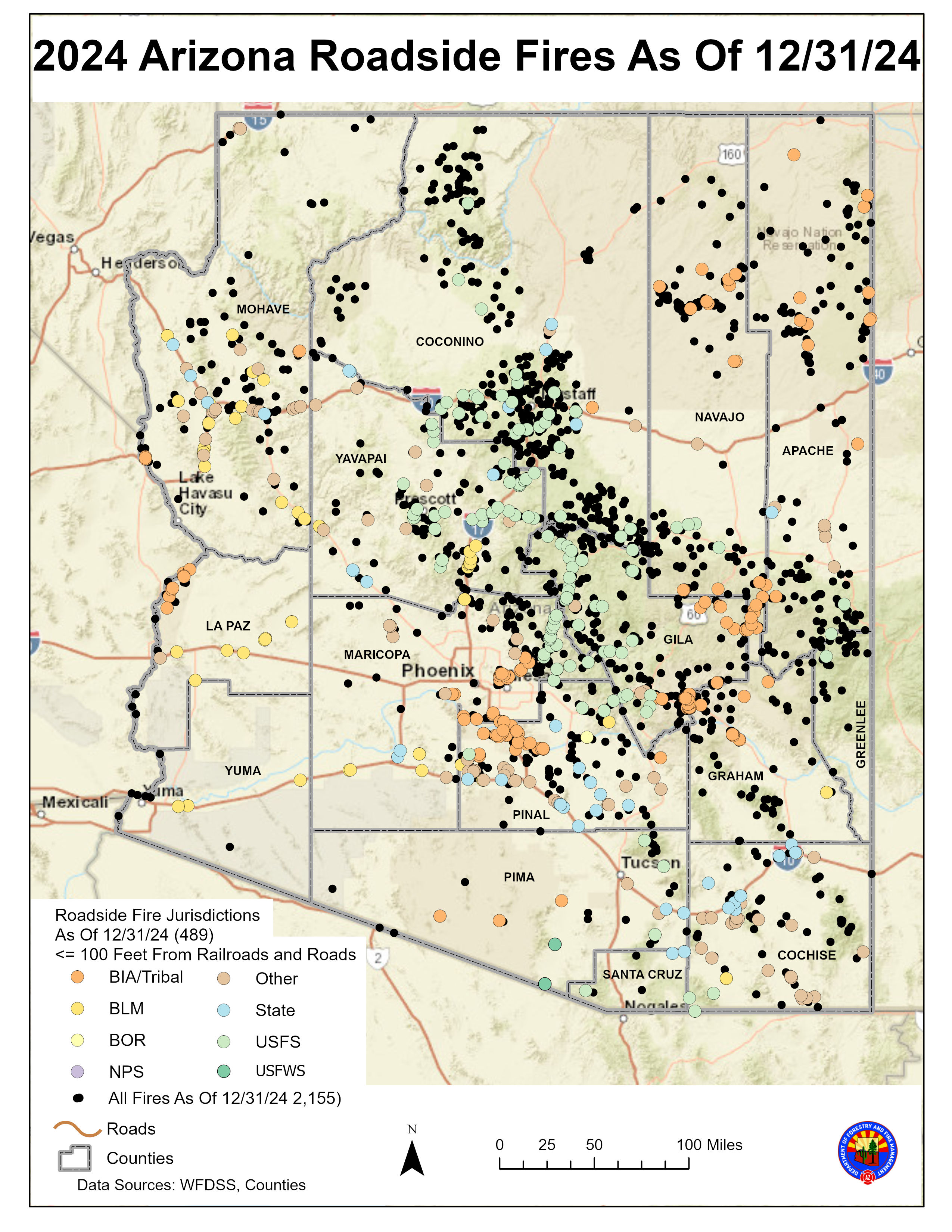
 

Roadside Fires End of Year Data


Driving and Wildfire Prevention Tips: 

  • Always check your tow chains to ensure they are secure. One spark is all it takes from a dragging chain to start a wildfire. 
  • Before getting on the road, check that your vehicle is in good working order, including the tires. Tire blowouts have also been known to cause wildfires. 
  • Never pull your vehicle off the road into vegetation. The undercarriage of the vehicle is extremely hot and can start a fire. 
  • Do not throw cigarette butts out the window. Keep our state free of litter and wildfires. 


Additional Wildland Fire-Related Information 

  • Arizona Wildland Fire Equipment Mobilization Guide 
  • AZ Burns Planned for Today
  • AZ Dept. of Environmental Quality 
  • AZ Emergency Information Network

Southwest Interagency Coordination Center 

  • SWCC Morning Situation Report 
  • SWCC Twitter - @SWCCNewsNotes
  • SWCC Summary SIT Report - By Protection 
  • SWCC Summary SIT Report - By Ownership

National Products and Websites 

  • National Situation Report
  • Inciweb
  • Enterprise Geospatial Portal (EGP)
  • ROSS Self Status
  • NAP


Tweets by @azstateforestry

Arizona State Seal
Contact Us
Department of Forestry and Fire Management
1110 West Washington St #500
Phoenix, AZ 85007
Find in Google Maps
Phone: (602) 771-1400
Map Image

Footer Nav

  • Statewide Policies
  • Site Map