  • State of Arizona
  • Visit OpenBooks
  • Ombudsman Citizens Aide
  • Register to Vote
Department of Forestry and Fire Management Logo
Department of Forestry and Fire Management
  • Home
  • Newsroom
    • Public Affairs
    • Fire Restrictions
    • Public Records
  • Fire
    • Wildland Fire Suppression
    • Prevention
    • Wildfire Information
      • Tips
      • Be Ready
      • Drones and Wildfire
    • State Forestry Crews
    • Cooperators and Fire Business
      • Fire Business Systems - Program Training
      • Emergency Medical Services on Federal Lands
      • Wildfire Equipment Program
    • Dispatch
    • Training
  • Forestry
    • Tree Care
    • Urban and Community Forestry
    • Stewardship
    • Legacy
    • Forest and Woodland Health
    • Utilization and Marketing
  • Grants
    • Community Forestry Grants
    • Forest Health Grants
      • Western Bark Beetle Initiative Grants
      • Invasive Plant Grants
    • Training and Equipment
      • 2024 American Rescue Plan Act (ARPA) Grant
    • Hazard Fuels Mitigation
    • Forest Utilization Grants
    • Landscape Scale Restoration Grants
    • Post-Wildfire Infrastructure Assistance Program
  • All Hazard Response
  • Fire Marshal
    • Arizona State Statute and Fire Code
    • Plan Review - Permitting and Inspection Information
    • Fire Safe Cigarettes
      • FSC Compliance and Forms
    • Food Truck Inspection, Letter of Appointment (LOA), Trampoline Courts
    • Firefighter Relief and Pension Fund
    • Arizona NFIRS: National Fire Incident Reporting System
    • Fire Prevention
  • About
    • Contact Us
Dry Conditions Statewide Could Fuel High Fire Activity Across Arizona
***NEW*** White Mountain Coordinating Group Implementing Stage 1 Fire Restrictions - February 27-2025
Arizona Forestry Successfully Treats More than 9,000 Acres During Spring Burn Window - September 27, 2023
  • Home
  • Fire
  • Prevention

Prevention

Arizona At Risk Communities

  • Read more about Arizona At Risk Communities

Arizona WRAP - Technical Information

Arizona WRAP (Arizona Wildfire Risk Assessment Portal):

The Arizona Wildfire Risk Assessment Portal (AZ WRAP) will be the primary mechanism for the Arizona State Forestry to deploy wildfire risk information and create awareness about wildfire issues across the state. It is comprised of a suite of applications tailored to support specific workflow and information requirements for the public, local community groups, private landowners, government officials, hazard-mitigation planners, and wildland fire managers. Collectively these applications provide the baseline information needed to support mitigation and prevention efforts across the state.

The portal provides access to wildland fire risk assessment data finalized in 2013 as part of the West Wide Wildfire Risk Assessment (WWA),

West Wide Wildfire Risk Assessment:

The Oregon Department of Forestry (ODF), on behalf of the Council of Western State Foresters (CWSF) and the Western Forestry Leadership Coalition (WFLC), conducted a wildfire risk assessment and report for the 17 western states and selected U.S. affiliated Pacific Islands. At the highest level, this assessment completed in 2013 is known as the West Wide Wildfire Risk Assessment, or WWA.

The basic risk assessment model used in the West Wide Wildfire Risk Assessment includes three primary outputs: the Fire Risk Index, the Fire Threat Index and the Fire Effects Index.   Webster’s dictionary defines risk as “the possibility of suffering harm or loss.”  Within the WWA, the data layer that defines wildland fire risk is the Fire Risk Index (FRI), while the “possibility of suffering harm or loss” is represented by the Fire Threat Index (possibility) and the Fire Effects Index (harm or loss).  The Fire Risk Index is calculated from the Fire Threat Index (FTI) and the Fire Effects Index (FEI).

Detailed information about the WWA risk assessment model and source data is found in the following reports:

  • WWA Detailed Process Description - PDF
  • WWA Final Report (Full Report) - PDF


  • Read more about Arizona WRAP - Technical Information

Arizona Wildfire Risk Assessment Portal

AZWRAP image


Do you live in a wildfire prone area? Do you know if your property is in a low risk or high risk area? Through the use of our Arizona Wildfire Risk Assessment Portal - or AZ WRAP - you can find your property and the surrounding neighborhood to determine the level of risk your area faces. The portal is an excellent tool to help the Arizona Department of Forestry and Fire Management provide wildfire risk information and create awareness about wildfire issues throughout the state. 


AZ WRAP is comprised of a suite of applications tailored to provide specific information for the public, local community groups, private landowners, government officials, hazard-mitigation planners, and wildland fire managers. Collectively these applications will provide the baseline information needed to support mitigation and prevention efforts across the state.


  • Read more about Arizona Wildfire Risk Assessment Portal

Fire Prevention

PHOENIX -- A coalition of Arizona-based agencies has an important message for everyone heading outdoors this summer: Be a responsible recreationist.

  • Read more about Fire Prevention

Poster Contest Honorable Mention #4

  • Read more about Poster Contest Honorable Mention #4

Poster Contest Honorable Mention #1

  • Read more about Poster Contest Honorable Mention #1

Community Wildfire Protection Planning

Destructive wildland fires in 2002 were a catalyst for Congress to pass the Healthy Forests Restoration Act (HFRA) in 2003.


The intent of the HFRA was to provide funding and guidance for better forest management practices throughout wildland areas and the wildland urban interface.


One of the key outcomes of the HFRA was to incentivize communities to create a Community Wildfire Protection Plan, simply known as a CWPP.


An approved CWPP can influence and prioritize future funding for hazardous fuel reduction projects, including where and how federal agencies implement fuel reduction projects on federal lands.


More information on CWPPs can be found on the national Forests and Rangelands website. 


Three Basic Criteria for CWPPs

  • Collaboration: A CWPP must be collaboratively developed by local and state government representatives, in consultation with federal agencies and other interested parties.
  • Prioritized Fuel Reduction: A CWPP must identify and prioritize areas for hazardous fuel reduction treatments and recommend the types and methods of treatment that will protect one or more at-risk communities and essential infrastructure.
  • Treatment of Structural Ignitability: A CWPP must recommend measures that homeowners and communities can take to reduce the ignitability of structures throughout the area addressed by the plan.


CWPP Guidance Requirements - Updated 2024 

***New*** CWPP Template

*A more detailed template is available upon request


Every year, the Arizona Department of Forestry and Fire Management analyzes communities across the state to determine which ones are at risk for a catastrophic wildfire. To see the list of communities at risk, please visit our Arizona At Risk Community page. 


However, through programs, such as Firewise USA, we work with communities, HOAs, and municipalities to evaluate their risk factors, and if necessary, take the imperative steps of working to reduce the chances of devastating wildfires burning through their communities. 


We also provide grant funding to help communities pay for fuels mitigation work in their area. The Department of Forestry and Fire Management also develops and implements project work across the state to reduce hazardous fuels and maintain the health of our forests. 


For additional information on the CWPP processes or procedures email CWPP Program Coordinator Karl Gehrke: [email protected].


  • Read more about Community Wildfire Protection Planning

Firewise USA™

When it Comes to Your Home - Wildfires Don't Have to be a Disaster

The Department of Forestry and Fire Management participates in National Fire Protection Association's Firewise USA™ program. The program teaches people how to adapt to live with wildfire. As a homeowner, there are simple things you can do to reduce the risk of your property from wildfire.


Living with Wildfire - Icon

    For more information on what you can do we encourage you to check out the Arizona 

    'Living with Wildfire' booklet.


    Is your community already FIrewise USA™ recognized?  

    Map  List


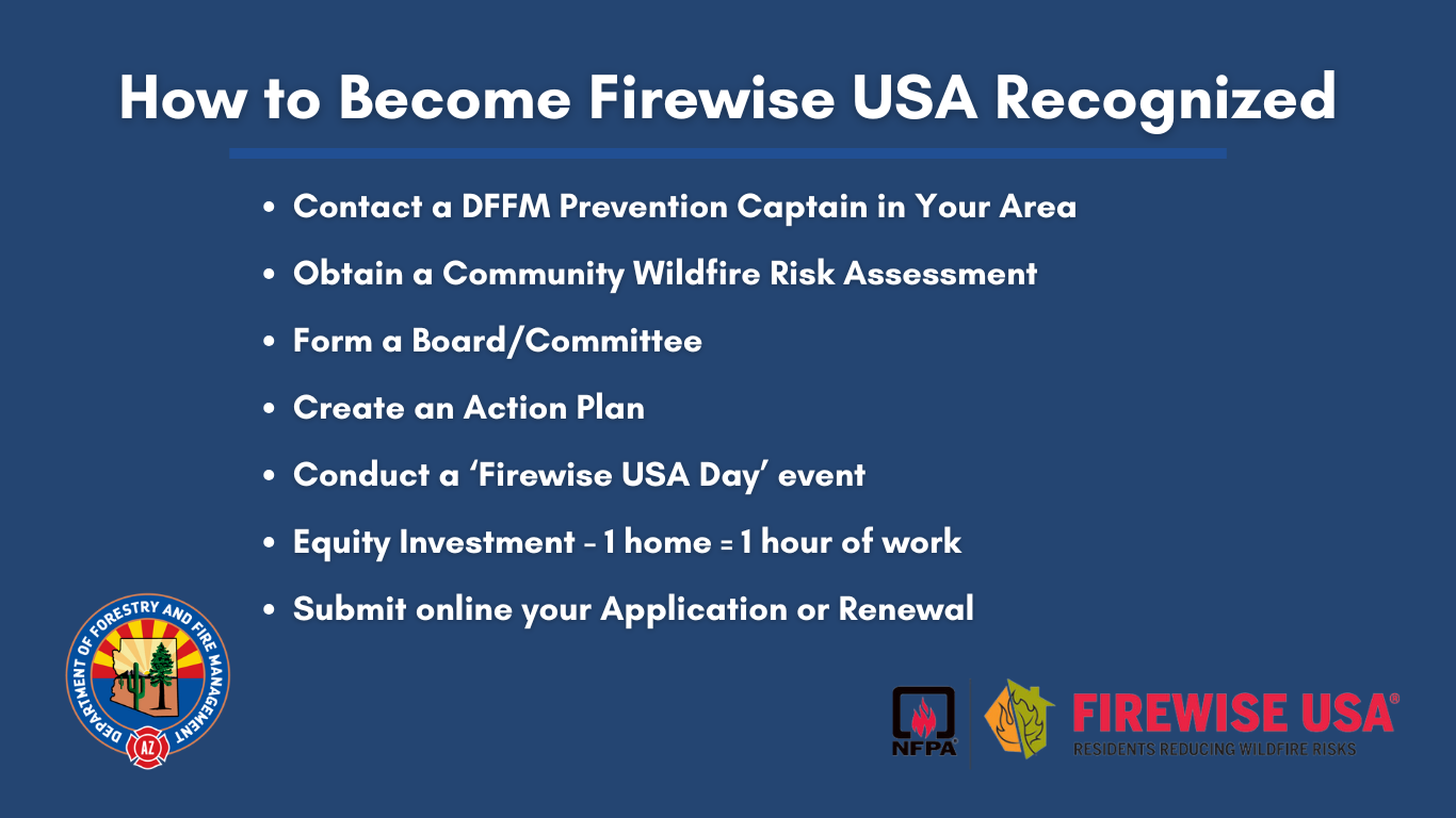
Join the Firewise USA™ Program

The Department of Forestry and Fire Management is the NFPA's Firwise USA liaison for the state of Arizona. DFFM works with homeowners associations, communities, and neighborhoods across the state to conduct Firewise USA training opportunities for residents. In turn, the residents work with DFFM to manage their sites and ensure they are meeting all Firewise USA requirements annually. 


Firewise USA Recognition How-To


Firewise USA™ Contacts in Your Area: 

Northern Arizona Zone: Mohave, Coconino, and Yavapai Counties: Captain Matt Rust 

Southwest, Central, and Northeast Zone: Apache, Navajo, Maricopa, Yuma, La Paz, Graham, and Greenlee Counties: Captain Chris Reed

Southern/Southeast Zone: Gila, Pinal, Pima, Cochise, and Santa Cruz Counties: Captain Mike Deleskiewicz


Firewise USA™ Community Recognition

In 2023, the Department of Forestry and Fire Management helped bring on 30 new Firewise USA-recognized communities across the state and led the southwest with the number of new sites for 2023. Congratulations to our newest communities: 


Coconino County 

Pinnacle Pines - Flagstaff


Gila County 

Rim View Heights - Payson 


Maricopa County 

DC Ranch - Scottsdale

Quail Ridge - Scottsdale

Sincuidados - Scottsdale

Sonoran Estates - Scottsdale

Winfield - Scottsdale 


Navajo County 

Bison Ridge - Pinetop

Country Pines - Pinetop 

High Country Village - Pinetop

Pine Lake Meadow - Pinetop

Pinetop Country Club - Pinetop

Pinetop Lakes Association - Pinetop

Quality Hill HOA - Pinetop

Quality Hill HOA Phase 2 - Pinetop

Quality Hill HOA Phase 4 - Pinetop

Rainbow Cove - Pinetop

Starlight Ridge Estates HOA - Pinetop

Starlight Ridge Estates Townhomes HOA - Pinetop

The Overlook at Bison Ranch - Pinetop

The Shores at Rainbow Lake - Pinetop 

The Timbers - Pinetop


Pima County 

La Canada Desert Homes 1 - Green Valley 

Portillo Ridge HOA - Green Valley 

Solar de Viejo HOA - Green Valley 

The Springs at Santa Rita - Green Valley 


Pinal County 

Superstition Foothills - Gold Canyon 


Yavapai County 

Crossroads Ranch II - Prescott

Forest Hylands Townhomes - Prescott

LaBarranca II - Sedona


In total, Arizona has 154 Firewise USA sites throughout the state with more communities and HOAs in the participation pipeline. We encourage you to take the time to speak with your neighbors, your community associations, and HOAs to work on bringing your area onto the Firewise USA platform. It takes all of us to do our parts to reduce the risk of devastating wildfires from threatening our homes and our Arizona communities. A home and a community that has clear defensible space is more likely to survive a wildfire, plus it keeps our firefighters on the ground safe when they are working to save your property.


Links: 
Firewise Communities Program
  • Read more about Firewise USA™

Tweets by @azstateforestry

Arizona State Seal
Contact Us
Department of Forestry and Fire Management
1110 West Washington St #500
Phoenix, AZ 85007
Find in Google Maps
Phone: (602) 771-1400
Map Image

Footer Nav

  • Statewide Policies
  • Site Map