  • State of Arizona
  • Visit OpenBooks
  • Ombudsman Citizens Aide
  • Register to Vote
Department of Forestry and Fire Management Logo
Department of Forestry and Fire Management
  • Home
  • Newsroom
    • Public Affairs
    • Fire Restrictions
    • Public Records
  • Fire
    • Wildland Fire Suppression
    • Prevention
    • Wildfire Information
      • Tips
      • Be Ready
      • Drones and Wildfire
    • State Forestry Crews
    • Cooperators and Fire Business
      • Fire Business Systems - Program Training
      • Emergency Medical Services on Federal Lands
      • Wildfire Equipment Program
    • Dispatch
    • Training
  • Forestry
    • Tree Care
    • Urban and Community Forestry
    • Stewardship
    • Legacy
    • Forest and Woodland Health
    • Utilization and Marketing
  • Grants
    • Community Forestry Grants
    • Forest Health Grants
      • Western Bark Beetle Initiative Grants
      • Invasive Plant Grants
    • Training and Equipment
      • 2024 American Rescue Plan Act (ARPA) Grant
    • Hazard Fuels Mitigation
    • Forest Utilization Grants
    • Landscape Scale Restoration Grants
    • Post-Wildfire Infrastructure Assistance Program
  • All Hazard Response
  • Fire Marshal
    • Arizona State Statute and Fire Code
    • Plan Review - Permitting and Inspection Information
    • Fire Safe Cigarettes
      • FSC Compliance and Forms
    • Food Truck Inspection, Letter of Appointment (LOA), Trampoline Courts
    • Firefighter Relief and Pension Fund
    • Arizona NFIRS: National Fire Incident Reporting System
    • Fire Prevention
  • About
    • Contact Us
Dry Conditions Statewide Could Fuel High Fire Activity Across Arizona
***NEW*** White Mountain Coordinating Group Implementing Stage 1 Fire Restrictions - February 27-2025
Arizona Forestry Successfully Treats More than 9,000 Acres During Spring Burn Window - September 27, 2023
  • Home
  • AZUTM Resources

AZUTM Resources

  • AZUTM Home
  • About
  • Resources
  • Upload
  • Community Inventories

I-Tree Streets Climate Zones in Arizona

Arizona Tree Guides

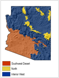
Urban tree field guides tailored for volunteers and citizen scientists in Arizona. The guides are split into three of i-Tree Streets climate zones but feel free to mix and match the guides for your community.
i-Tree Streets' economic and environmental tree value analysis are based on reference cities within STRATUM Climate Zones developed by USDA-FS. Not until you upload your data to AZUTM to run the analysis, do you have to decide on a climate zone.

 
PDF Download  AZUTM Field Guide - Southwest Desert  04 /28/2015
Tree identification guide for select horticultural tree species found in Arizona and listed in i-Tree Streets' Southwest Desert climate zone. 
PDF Download  AZUTM Field Guide - Interior West  04/28/2015
Tree identification guide for select horticultural tree species found in Arizona and listed in i-Tree Streets' Interior West climate zone.
PDF Download  AZUTM Field Guide - North  04/28/2015
Tree identification guide for select horticultural tree species found in Arizona and listed in i-Tree Streets' North climate zone.
PDF Download  AZUTM Field Guide - Insects and Diseases   05/21/2015
Guide to common insect and diseases that affect Arizona's horticultural trees.
PDF Download  AZUTM Master Tree Index - 06/01/2015 
Master index of tree species found in AZUTM Guides listing their scientific names, common names, species codes, and page numbers.

Tree Inventory Guides and Templates

How-to manuals for tree inventories and template files for communities to get a leg up on their own urban forest inventories. Feel free to modify the template files to your liking. See the "AZUTM - Tree Inventor Instruction Guide" for detailed instructions.

PDF Download  AZUTM Tree Inventory Instruction Guide  5/15/2015 
Inventory and technical manual on how to collect tree measurements, observations, and how to submit inventories to AZUTM for analysis. 

PDF Download  Understanding Your AZUTM Reports Guide  9/28/2015
Guide to AZUTM's custom i-Tree Streets reports with tree structure and benefits analysis results for your submitted tree inventories. 

Download Word document  AZUTM Tree Data Collection Form Template  12/15/2014
Paper-based data collection template used in the field.

Download Excel document  AZUTM Tree Inventory Spreadsheet Template  02/04/2015
MS Excel spreadsheet template used to digitally summarize tree inventories and upload to AZUTM's tree structure and benefits analysis tool.

Download Excel document  AZUTM DBH Calculator 09/29/2015 
MS Excel spreadsheet that helps calculate the combined Diameter at Breast Height (DBH) of trees with multiple trunks.

Arizona Urban Tree Canopy Cover Analysis

i-Tree Canopy analysis reports (PDF) for Arizona's largest Cities and Towns. The 2015 analysis reports provide % tree canopy cover and tree benefit estimates for over 97 communities and were used to estimate the average urban tree canopy cover for Arizona's Counties. See reports below or AZUTM Interactive Maps.

The canopy cover estimates should not be taken as an absolutes but as a comparative estimate between Arizona’s major towns and cities.

  • Download Excel document 2016 Arizona Urban Tree Canopy Cover by County Summary Table
  • Download Excel document 2016 Arizona Urban Tree Canopy Cover by City Summary Table

The i-Tree Canopy analysis were based on municipal incorporated areas unless otherwise stated.

  • Urban = 2010 Census Urban Areas
  • Intersection = intersection between Census Urban Areas and incorportated areas.

PDF Download Canopy Cover Reports A - G

PDF Download Canopy Cover Reports H - R

PDF Download Canopy Cover Reports S - Z

  • Apache Junction
  • Avondale (Intersection)
  • Benson (Intersection) 
  • Bisbee (Urban)
  • Blyth (Urban)
  • Buckeye (Urban)
  • AZUTM_i-Tree_Canopy_report_BullheadCity.pdfBullhead City (Intersection)
  • Camp Verde (Urban)
  • Carefree (Intersection)
  • Casa Grande (Urban)
  • Cave Creek
  • Chandler (Urban)
  • Chinle (Intersection)
  • Chino Valley (Intersection)
  • Clarkdale (Intersection)
  • Clifton (Urban)
  • Colorado City
  • Coolidge
  • Cottonwood (Intersection)
  • Dewey Humboldt
  • Douglas (Intersection)
  • Duncan
  • Eager
  • El Mirage
  • Eloy (Intersection)
  • Flagstaff (Urban)
  • Florence (Urban)
  • Fountain Hills
  • Fredonia
  • Gila Bend
  • Gilbert
  • Glendale
  • Globe
  • Goodyear (Intersection)
  • Green Valley (Intersection, 2017 update)
  • Guadalupe
  • Hayden
  • Holbrook (Intersection)
  • Huachuca City
  • Jerome
  • Kayenta (Urban)
  • Kearny
  • Kingman
  • Lake Havasu City (Urban)
  • Litchfield Park
  • Mammoth
  • Marana (Intersection)
  • AZUTM_i-Tree_Canopy_report_Maricopa.pdfMaricopa (Intersection)
  • Mesa
  • AZUTM_i-Tree_Canopy_report_Miami.pdfMiami (Intersection)
  • Nogales (Urban)
  • Oro Valleye
  • Page (Intersection)
  • Paradise Valley
  • Parker (Intersection)
  • Patagonia
  • Payson (Urban)
  • Peoria
  • Phoenix
  • Pima (Intersection)
  • Pinetop Lakeside
  • Prescott
  • Prescott Valley (Intersection)
  • Quartzsite (Urban)
  • Queen Creek
  • Safford (Urban)
  • Sahuarita (intersection, 2017 update)
  • San Carlos (Urban)
  • San Luis (Intersection)
  • Scottsdale
  • Sedona (Urban)
  • Show Low
  • Sierra Vista
  • Snowflake
  • Somerton (Intersection)
  • South Tucson
  • Springerville
  • Star Valley
  • St. Johns (Intersection)
  • AZUTM_i-Tree_Canopy_report_Superior.pdfSuperior (Intersection)
  • Surprise
  • Taylor (Intersection)
  • Tempe
  • Thatcher (Intersection)
  • Tolleson
  • Tombstone
  • Tucson (Intersection)
  • Tusayan
  • University of Arizona Planning Area
  • Wellton
  • Wickenburg (Intersection)
  • Willcox (Intersection)
  • Williams (Intersection)
  • Winkelman
  • Winslow (Intersection)
  • Youngtown
  • Yuma (Urban)

Urban and Community Forestry Documents

  • PDF Download AZSF - Urban Forests Needs Assessment 2012  

Online Resources

Following are links to helpful urban tree inventory related resources:

  • Tree Identification & Species Codes
    • USDA-NRCS PLANTS Database - Lookup USDA species codes and more!
  • Tree Identification
    • Encyclopedia of Life
    • Gymnosperm Database
    • Department of Horticulture, Oregon State University
    • SEINet Southwest Environmental Information Network
    • SelecTree
    • Tropicos
    • University of Arizona Campus Arboretum
    • Forest Resources and Environmental Conservation, Virginia Tech
  • Insect and Diseases
    • BugGuide.net
    • BugWood.org
  • Valuing Tree Benefits
    • i-Tree Streets
    • National Tree Benefit Calculator
  • Miscellaneous
    • Forestry Images 
    • 2010 USDA FS Urban Forest Analysis  

Mobile Tree Inventory Apps

For volunteer-driven inventories, we continue to search for an affordable smartphone app and web-based data storage service that allows for customized tree inventory and GPS location capture under intermittent network conditions. Here are some partial solutions:

  • GIS Cloud - commercial online service for creating and managing custom mobile forms and collaborative maps; also collects GPS location, photos, audio, etc.; works offline
  • i-Tree Mobile Data Collection - free, mobile data collection web application that ties in with i-Tree Streets and Eco; requires constant internet access
  • Open Data Kit (ODK) - free, open-source tool set for mobile data collection solutions; requires moderate software configuration skills and your own ODK web server
  • Tree Plotter (Plan-It Geo) - fully featured commercial online service; requires constant internet access
  • OpenTreeMap.org - commercial crowd-sourcing online service; requires constant internet access
  • DoForms.com - commercial online service for creating and managing custom mobile forms that can work offline

Disclaimer of Non-endorsement

Reference herein to any specific commercial products, process, or service by trade name, trademark, manufacturer, or otherwise, does not necessarily constitute or imply its endorsement, recommendation, or favoring by the Arizona Department of Forestry and Fire Management.. The views and opinions of individuals expressed herein do not necessarily state or reflect those of the agency, and shall not be used for advertising or product-endorsement purposes.
In accordance with Federal law and U.S. Department of Agriculture policy, this institution is prohibited from discriminating on the basis of race, color, national origin, sex, age, or disability. (Not all prohibited bases apply to all programs.) 

AZUTM Resource Sections

  • Arizona Tree Guides
  • Tree Inventory Guides and Templates
  • Arizona Urban Tree Canopy Cover Analysis
  • Urban and Community Forestry Documents
  • Online Resources
  • Mobile Tree Inventory Apps
  • Disclaimer of Non-endorsement

How To Print AZUTM Guides?

AZUTM Guides contain both Landscape and Portrait page orientations. Follow these guidelines to print all pages in the correct orientation (instructions may vary depending on the program used to open the PDF).

  • Select Print from File menu
  • Under the Page Handling (or Page Sizing and Handling) section of the Print dialog box,check Auto-rotate and scaling or Auto portrait/landscape
  • Under Page Scaling, check Fit to Printable Area or Fit
  • If your printer supports double sided printing, select Print on both sides, two-sided printing, or double sided printing from either the main Print menu or under Properties.

Tweets by @azstateforestry

Arizona State Seal
Contact Us
Department of Forestry and Fire Management
1110 West Washington St #500
Phoenix, AZ 85007
Find in Google Maps
Phone: (602) 771-1400
Map Image

Footer Nav

  • Statewide Policies
  • Site Map